Gifford Pinchot Mountain Bike Trails - Your Guide to World-Class Rides
I'm Justin Vander Pol, founder of Abit Gear. I was Evergreen Mountain Bike Alliance's first Executive Director and here I want to share my love of the big rides in the Gifford Pinchot.
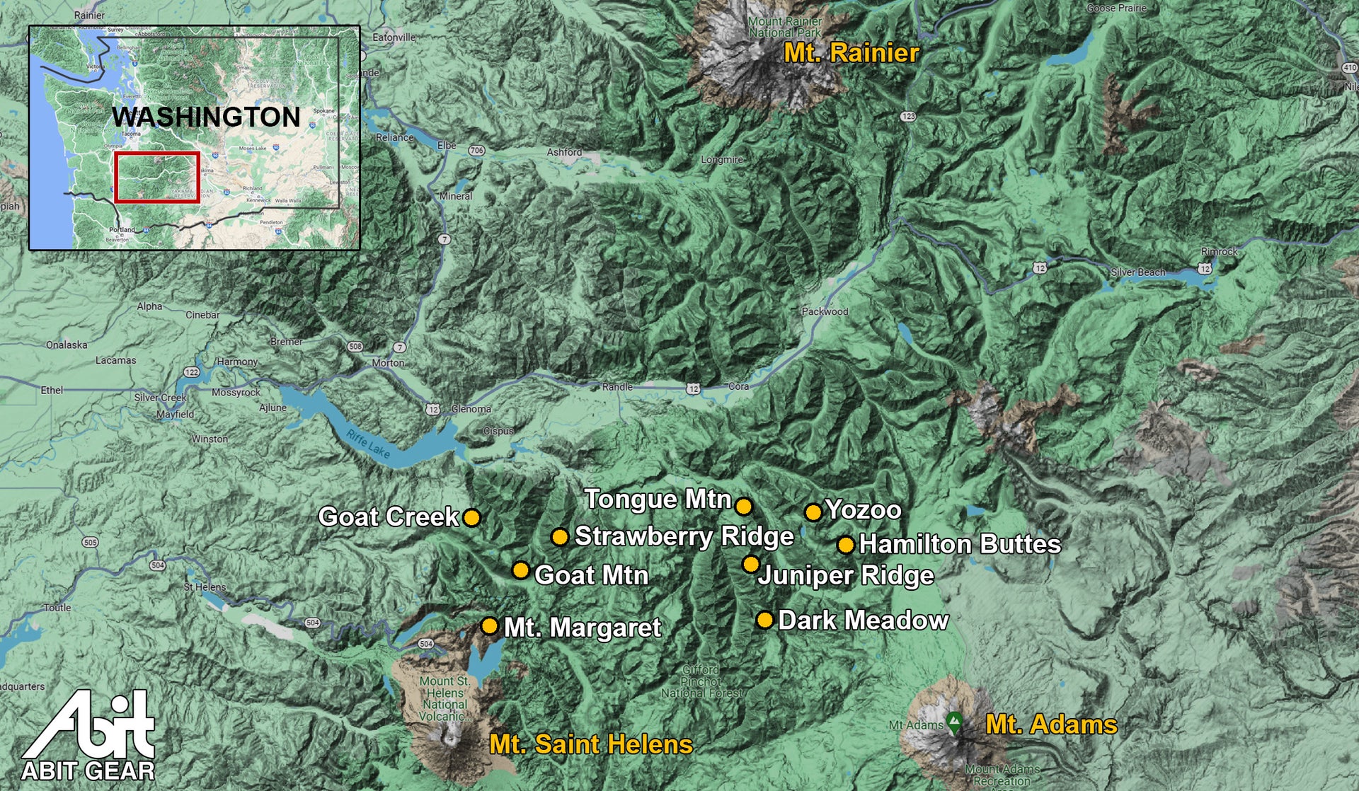
Here in Washington State we have a zone with some of the best riding in the world. Nestled between Mount St. Helens, Mt. Adams and Mt. Rainier is a section of the Gifford Pinchot National Forest that includes the Dark Divide. The riding here is epic with mind blowing views, crazy geology and massively long descents.
Some of these rides are point-to-point shuttles. An option is to use Trans Cascadia Excursions for private shuttles or their mountain bike day trips. I've used these folks, they're great.
A shout out to the Cowlitz-Naches Chapter of Evergreen Mountain Bike Alliance. This chapter is based in a lightly populated region with a massive amount of world-class trails to maintain. Consider throwing a little love their way or becoming a member.
The Best Descents in the Gifford Pinchot National Forest
- Strawberry Ridge: a crowd pleaser that is just plain fun. Complete with great views and a long descent. 9 miles, 3400 feet of singletrack descending, 800 feet of climbing. Strawberry Ridge ride info
- Juniper Peak to Tongue Mountain: the best descent! Everything from chonky moto-trail to flowy natural singletrack. 11 miles, 4200 ft descending (yesss!), 1900 ft climbing. Tongue Mountain ride info
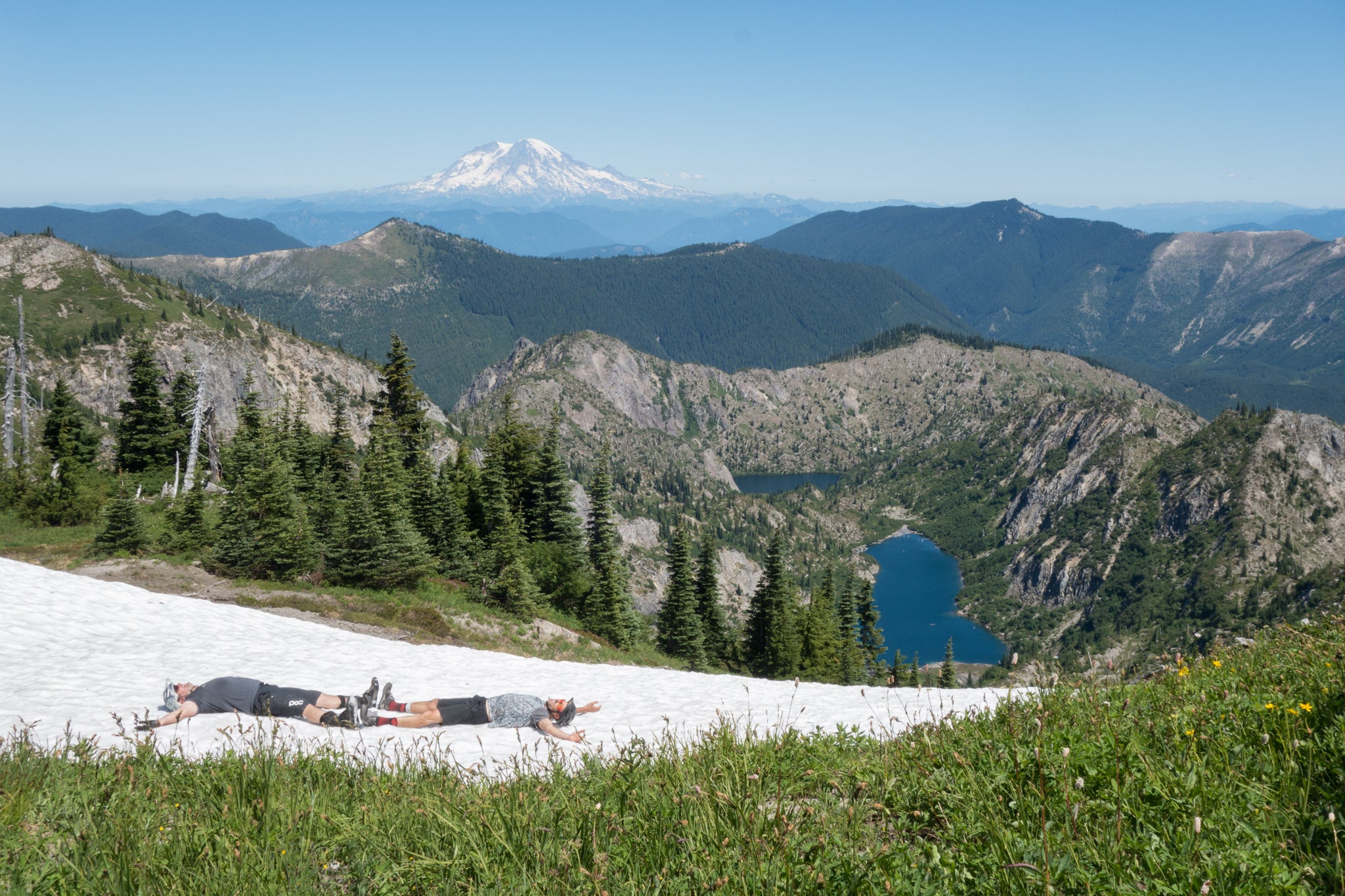
- Sunrise - Juniper Ridge - Dark Meadow: The descent isn't as long as the Juniper-Tongue ride above, but the scenery is a better. Really, you should do both of them if on a trip here! If shuttling the road this ride is 9 miles with 3500 ft of descending, 1500 ft of climbing. Dark Meadow ride info
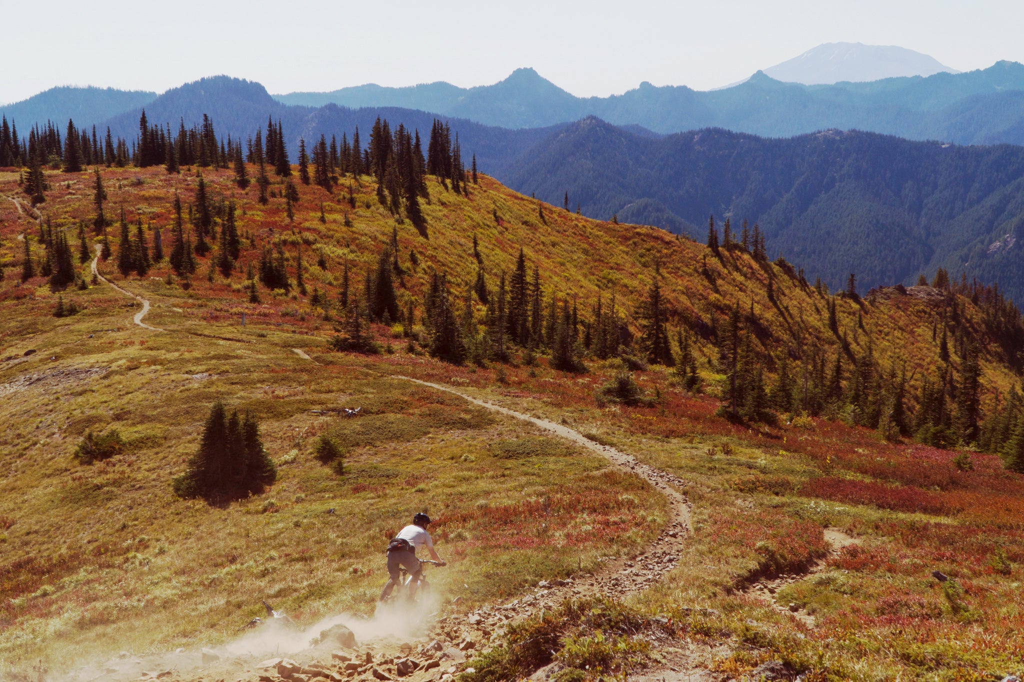
Descending Juniper Ridge, heading toward Dark Meadow
The Best Loop Rides in the Gifford Pinchot National Forest
Here's a selection of rides that are doable as loops so you don't need to deal with complicated vehicle logistics.
- Goat Mountain - Vanson Ridge - Green River: this the best "pure" MTB ride that has it all. Big cimbs, great descents, panoramic views, and is one of the routes that isn't open to motos so it's not rutty. There are a couple ways to make it even more epic, but the "classic loop" is a great way to start. 20 miles with 3400 feet of vert. Goat Mountain ride info
- Sunrise - Juniper Ridge - Dark Meadow: the same ride mentioned above, but instead of shuttling up road NF-2324 pedal up it. This is a great e-bike option. 16 miles, 3700 feet of vert. Dark Meadow ride info
- Hamilton Buttes: A nice ride on moto trail that isn't too rutty. This can be ridden as a loop starting at Cat Creek Chimney or as a shuttle. The road climb is nice mellow grade, pedaling the 5 miles and 1500 feet, with a few a longer view route and easier option from there. 13 miles, 2900 ft vert with some hike-a-bike to get the panoramic view, or 11 miles and 2500 ft for the easier option. Hamilton makes a great e-bike ride. Hamilton Buttes ride info
The Best View Rides in the Gifford Pinchot National Forest
There's a LOT of amazing views out here, and many points where you can see all three of the big volcanoes at once. It's nuts out here, such a special place.
- Boundary Trail from the Norway Pass TH to Mount Margaret: amazing views over Spirit Lake to Mount Saint Helens. Quite possibly the most stunning view ride I've ever done. It's a rugged landscape that was scoured clean by the huge tidal wave created when Saint Helens slid into Spirit Lake during the eruption. I've got more on this fascinating history below. Boundary Trail to Mount Margaret ride info
- Sunrise - Juniper Ridge - Dark Meadow: yeah, the same ride mentioned twice above. This ride offers it all as long as you enjoy a rowdy descent (which we do!). If going for views make sure to do the grunty, sucky push up to Sunrise Peak. Dark Meadow ride info
- Goat Mountain: get up to Vanson Peak for panoramic views, but the whole Goat Mountain ridgeline delivers. Goat Mountain ride info
- Strawberry Ridge: noticing a theme? Yep, the same Strawberry in our best descents list. The southeast aspect of Strawberry is in the Mount Saint Helens Blast zone with views of Saint Helens. Strawberry Ridge ride info
The Best Epic Rides in the Gifford Pinchot National Forest
- Goat Mountain: It's the best loop, as listed above, but you can make it even more epic by starting on Goat Creek for a 28 mile, 6200 feet of vert ride all on singletrack with the bonus that you get to ride behind a waterfall. Goat Mountain ride info
- Yozoo - Hamilton Buttes: If your a hammerhead who loves a good sufferfest then Yozoo-Hamilton will be your cuppa. It feels like more climbing than descending, but it's definitely epic and offers a nice mid-ride swim in Blue Lake. Yozoo - Hamilton Buttes ride info
Boundary Trail from Norway Pass Trailhead to Mount Margaret
This ride is all about the views of the crazy aftermath of the Mount Saint Helens eruption in 1980. Only do this ride on a clear day, the descent would be fun by most standards, but isn't one of the top Gifford descents. If going for Saint Helens views, this ride blows the popular Ape Canyon - Plains of Abraham ride out of the water; literally blown out of the water, keep reading for more about this.

Spirit Lake and Mount Saint Helens from Mount Margaret
You're riding on the pumice ejected in the eruption, there's no water on the trail, and almost no shade. Because of the soft trail surface the ride is more physical than the stats would indicate and it's hot. Bring more food and water than you think you need, take your time to enjoy the amazing views everywhere, and bring your big camera for this one.
Since this ride is all about the views and geology, only do it on a clear day. The first few miles from the Norway Pass trailhead gets busy with hikers, so you're better doing this ride on a weekday. With all of that out of the way, prepare to blow your mind with dramatic views and volcanic eruption geology.

The ride is an out-and-back starting at the Norway Pass trailhead on road FS-26. The roads getting here are mostly paved, but be aware of the unmarked slumps and dips that can absolutely slam your car.
You'll pedal 11 miles with 2100 feet of vert. I'll mention again that you're riding on pumice, so it's quite physical for a ride of this size. Most of the trail can be pedaled, but you'll be pushing the steeper sections. Norway Pass to Mt. Marget rideplan on TrailForks
Mount Saint Helens Eruption and the Spirit Lake Tidal Wave
The dramatic landscape on this ridge was formed by the eruption of Mount Saint Helens in 1980. When the volcano erupted, the north flank of the mountain slid into Spirit Lake in the largest landslide ever recorded. This pushed the water from the lake up onto the ridge you're riding, scouring it clean and sweeping all the trees down into Spirit Lake. These trees are still floating in the lake, which you can see in the first picture in this section.

Climbing toward Mt. Margaret. The area was swept clean of trees and topsoils in the tidal wave created by Mount Saint Helens sliding into Spirit Lake when it erupted.
Volcanic activity and mudflows from Mount St. Helens created Spirit Lake roughly 3,000 years ago. But the 1980 eruption nearly blasted it to extinction. A debris avalanche, triggered by the eruption, slammed into the lake like an enormous tidal wave, sweeping water out of the lake basin northward and up the steep slopes of nearby Mount Margaret. Some water may have spilled over Margaret’s summit—about 800 meters above the lake’s surface. - Science After the Volcano Blew | American Scientist
Dark Meadow
This is one of the best descents in the Gifford, and this ride has it all. Hike-a-bike, panoramic views, open ridgelines and a ripping descent on moto trail. It's a more technical descent than Strawberry Ridge or Hamilton Buttes, advanced riders and downhillers (who don't mind climbing) will love this one.

The shuttle version of the ride shown above is 9 miles, 3500 feet descending with 1500 feet of climbing. The first section on Sunrise has a bunch of hike-a-bike, as you'd expect in the Gifford. Dark Meadow Trail on TrailForks
The road shuttle is passable as of 2023. There was a washout, but you can get through it just fine. It's a bit steep on gravel once you make the final turnoff up to the trailhead, but I was able to do it in my 2WD minivan with good traction tires.
Add 1.5 miles and 700 ft of rutty hike-a-bike if you opt to push up to Sunrise Peak for the panoramic views. It's a nasty push, but worth it for the views.

Kevin riding Juniper Ridge between Sunrise and Jumbo Peak
The Sunrise - Juniper Ridge - Dark Meadow ride also makes a great loop if you're looking for a longer pedal, don't want to hassle with shuttle logistics or want a great e-bike ride.
The loop option adds on the 6 mile, 2700 foot climb up road NF-2324. This loop, including the Sunrise Peak option, is 16 miles with 3700 feet of vert. Sunrise - Juniper Ridge - Dark Meadow loop ride plan on TrailForks
Goat Mountain and Goat Creek
There's whole variety of ways to ride Goat Mountain, and we'll start with the "classic loop", which I'd call a mini-epic. Big climbs, big views, a big descent, all on singletrack.

Start at the Goat Mountain trailhead near Ryan Lake. Or better yet, camp at the Green River Horse Camp and start there. You get the steeep initial climb (some pushing) done right out of the gate, and then get nice view ridgeline. Stop at Deadman's lake for a water filter refill and a nice swim.
Make your way up to Vanson Peak and enjoy stunning views of three volcanoes. Once you're done with that you get the absolute treat of a fast, buff descent down Vanson Ridge before the gentle (with a few little punches) climb back to where you started.
This version is 20 miles with 3400 feet of vert and plenty of water along the way if you want to bring a filter. Goat Mountain classic loop ride plan on TrailForks

John riding the Goat Mountain ridgeline
The epic version of Goat is to start at the Goat Creek trailhead and come in from the north. This adds 10 miles and 2500 feet of vert to the ride, plus you get to ride behind Cathedral Falls (it dries up mid-summer). Check trail reports before coming from Goat Creek as it can have a lot of blowdown. The Goat Creek Epic route is 28 miles with 6200 feet of vert. Goat Mountain Epic route on TrailForks
A third option is to out-and-back starting and Goat Creek and turning around at the bottom of Vanson Ridge. This route gets you all the best descents and views in the Goat zone. Add on a detour to Deadman's Lake for a swim if you have the time and legs. This route offers up 23 miles with 5500 feet of vert. Goat Creek - Vanson - Deadman's Lake T route on TrailForks
Hamilton Buttes
There are two ways to do Hamilton. The first is the view route, shown below, which includes the short out-and-back push up to Hamilton Butte. The views up here are stunning! The descent down Hamilton starts technical off the peak, and then becomes fairly chilled out, but fun, moto trail that has hardly any ruts. This route is 13 miles with 2900 feet of vert. Hamilton Buttes view route on TrailForks

The easier route takes the Hamilton Buttes trail from where it intersects road NF-78. Both the climb and descent going this way are appropriate for fit intermediates. This easier option is 11 miles and 2500 ft of vert, but you miss out on the amazing view up top.
The shuttle road NF-78 is clear to drive as of fall 2023, so the washout that TrailForks shows is out of date. Smooth and easy drive on gravel, any car can make it if you'd like to shuttle.
A note on getting here, DO NOT follow Google maps routing advice. Come in from Randle on road NF-23 to NF-21 on beautifully paved roads. Coming in from Packwood via the other side of NF-21 means an hour of annoying washboards and some really odd route suggestions from the Google overlords.
Juniper Ridge
Soooo Juniper. Let's talk about Juniper Ridge since it's a fairly well known ride. Each end of Juniper can be a riot of fun, but doing the whole thing means sucky pushing through thigh deep moto ruts. Not recommended. Instead, do the Tongue Mountain or Dark Meadow rides to maximize the best descents on Juniper. Juniper Ridge on TrailForks

Strawberry Ridge
It's the ride that almost every MTBer can do and that everyone loves. This point-to-point shuttle ride has a long descent, great views, isn't too gnarly, and is just plain fun. The southern portion of Strawberry Ridge is in the Mount Saint Helens blast zone, offering unique geology with amazing views of Saint Helens.


The route for this ride is simple, just drive up road NF-2516, which is fine in most vehicles, and then head north on Strawberry Ridge until you end at road NF-26.
The ride is 9 miles, 800 ft climbing, 3800 ft descending (500 ft of that on dirt road). Strawberry Ridge on TrailForks
Green River Trail from Strawberry to the Green River Horse Camp is another great descent that is worth doing, and puts you right at a great spot to camp. Green River Trail (Upper) on TrailForks
I've also pedaled starting at the Norway Pass trailhead, where Boundary Trail crosses road NF-26. This is a good option if you're looking to make this a bigger point-to-point ride. The views on this version of the route are even more stunning as you start out in the blast zone of Mount Saint Helens. Boundary Trail on TrailForks
Tongue Mountain with Juniper Peak Option
This is one of the best descents in the country! I highly recommend the extra effort to push/pedal the 3 miles/1800 ft of vert up to Juniper Peak as shown here. You get great views up top and a truly amazing descent that just goes, and goes, and goes.

You need to be OK with hike-a-bike and technical descending on moto trails. There's some ruts and some blown out chunk, but all in the best way possible. Lower down Tongue Mountain the trail turns into a perfect brown ribbon of singletrack through lush forest. This really is an amazing and long descent, and one of the best in all of Washington.
To do this ride, shuttle up road NF-2904 to the trailhead and turn right to push up Juniper Ridge Trail to Juniper Peak. At the peak turn around and shred back down to the end. The shuttle road is good, most vehicle should make it just fine. 
Scott riding on Juniper Peak with Mount Adams in the background
The Tongue Mt. ride with this out-and-back to Juniper Peak is 11 miles, 4250 ft of descending with 1900 feet of climbing. Juniper Peak to Tongue Mountain ride plan on TrailForks
A shorter option is to take Tongue Mountain down. Still a great 5 mile ride with 2500 feet of descending and only a 260 foot climb. Tongue Mountain Trail on TrailForks
Yozoo - Hamilton Buttes Epic
This is a ride for someone who is looking for a big day of riding, and as Clinton puts it on TrailForks, a "Proper GP Adventure". That means it's big, lots of hike-a-bike up moto ruts and fun descents. This one does feel like more climbing than descending, so you've been warned.

Lunch at Blue Lake before making the final push (literally) up to Yozoo
The ride is 25 miles and 5500 feet of vert... and it feels like more than that. Yozoo - Hamilton Buttes Epic rideplan on TrailForks

It looks like there's a few fun ways to ride this zone that I haven't tried. One is starting at Hamilton Peak, turning right on to the Hamilton Buttes trail, descend the first part of Yozoo, then looping back via the road to do the full Hamilton Buttes descent.
Another ride that has caught my eye is doing the above, but continue climb the north section of Yozoo, and then descend northwest on Bishop Ridge. This is apparently gnarly moto trail, but it looks like my kind of fun and would be a 5800 ft descent over 15 miles. Hopefully I'll go guinea pig this one next summer.